Destinations • Haʻapai • Kingdom of Tonga
Home · Cruising Guide · Tonga · Tonga clearance · Haʻapai Anchorages
Haʻapai Anchorages
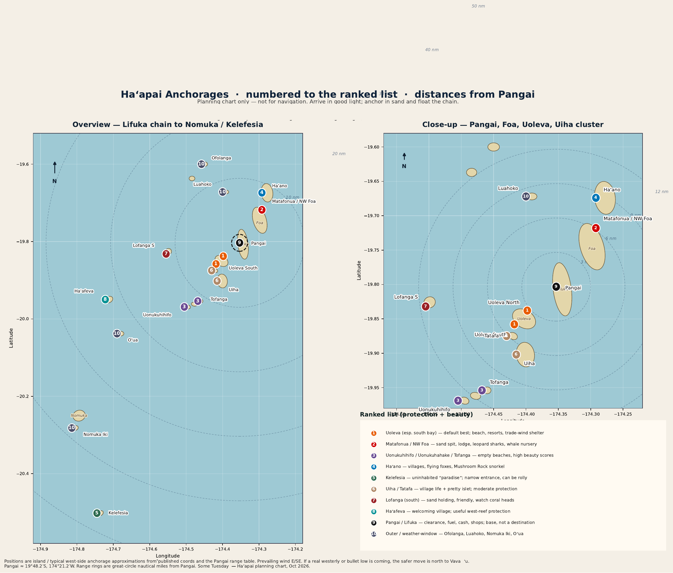
Numbered planning chart from Pangai. Not for navigation.
Haʻapai is the quiet middle child of Tonga’s island groups: fewer boats, fewer facilities, and some of the prettiest beaches and clearest water in the kingdom.
The trade-off is protection. Almost every well-regarded spot is excellent in the usual SE trades and settled weather, and almost none of them are comfortable in a strong westerly or when swell wraps over the reefs at high tide. Official cruising notes and local sailors routinely say that if a real westerly or a “bullet low” is coming, the safer move is north to Vavaʻu.
Rankings below combine community ratings (Navily, NoForeignLand), cruising blogs, and the Tonga Stopover Handbook. Beauty scores are high almost everywhere; protection is the thing that separates them.
By Steve and Meghan, SV Some Tuesday. This is the chart we keep next to the passage plan. The numbers on the map match the list. Pangai, on Lifuka, is number 9, and it sits at the center of the range rings, about 19°48.2′S, 174°21.2′W. We cleared into Tonga at Neiafu, in Vavaʻu. We have not cleared in at Pangai.
Planning numbers only, not for navigation.
See this area on NoForeignLand
Planning chart only. Arrive in good light. Anchor in sand and float the chain. Positions are typical west-side anchorages, not survey marks. Rings are 5, 10, 20 and 40 nautical miles from Pangai. A number that sits beside its dot was nudged so you can tap it. The dot is the planning mark.
Download the chart See the print chart
The ten places
We went is a visit of our own. Heard from cruisers is ratings, blogs, the handbook, and other boats. The ranked notes are the second kind. Pepa’s, under number 1, is the first.
-
1Uoleva (especially the south bay) Heard from cruisers
The default “best” for most cruisers. Long white sand beach, good sand holding, straightforward entry, and the best combination of shelter in S–NE winds plus easy access from Pangai. Several small resorts (Pepa’s, Serenity, Sea Change, kitesurf operations) mean you can eat ashore and arrange whale swims. Can get rolly in SE swell or if the wind goes west; there are tighter spots behind the reef if that happens. Very highly rated for both scenery and practicality.
-
2Matafonua / NW Foa (Matafonua Lodge / Sandy Beach area) Heard from cruisers
Stunning sand spit, crystal water, restaurant (burgers, pizza, cold beer), drift snorkeling with leopard sharks in the pass, and a classic whale-nursery location. Good holding in 4 m sand and solid protection from S through ENE. Entrance needs good light because of bommies. Slightly more “resort” feel than Uoleva but still quiet. Consistently 4.8-star reviews for scenery and shelter in the trades.
-
3Uonukuhihifo / Uonukuhahake / Tofanga Heard from cruisers
The “Robinson Crusoe” spots. Uninhabited (or nearly), huge sand patches, empty beaches, excellent snorkeling, and some of the highest beauty scores in the group (5.0 and 4.8 on NoForeignLand). Protection is good from NE through south; a bit of roll is possible. Holding is sand but you must watch coral heads and float the chain. These are the places people talk about years later.
Uonukuhahake is named with this group. The chart has no position for it, so it is not marked.
-
4Haʻano (north of Pukotala / Mushroom Rock) Heard from cruisers
Peaceful, villages to walk between, flying-fox trees, and a well-known snorkeling spot at Mushroom Rock. Protected from NE–SE but can take SE swell. Friendly locals, small stores. A solid “real Tonga” stop that is still pretty.
-
5Kelefesia (southern Nomuka group) Heard from cruisers
Frequently called a must-do or “paradise.” Uninhabited, dramatic little cliffs, birds, walk-around island, baby blacktips. Anchorage is a sandy patch inside a coral ring. Entrance is narrow and needs good light and low-ish tide; it can be rolly when swell comes over the reef at high water. Further from Pangai, so it is more of a passage stop or a dedicated expedition than a day hop.
-
6Uiha / Tatafa Heard from cruisers
Village access, sandy bottom, usable in trades. Tatafa is prettier; Uiha has more community life (small shops, school). Protection is only moderate and south swell can make Tatafa uncomfortable. Fine for a night or two, not the first choice if you want flat water and postcard views.
-
7Lofanga (south side) Heard from cruisers
High community ratings (5.0) for holding in sand, friendly people, and a quiet setting. Coral heads are plentiful so you need to be careful and float chain. Best in calmer weather or NW winds. Less famous than Uoleva or Matafonua but well liked by those who go.
-
8Haʻafeva Heard from cruisers
Very welcoming village, some provisioning, and the reef gives useful protection from the west—one of the few spots that is not completely open to that direction. Further out (~22 nm). More “local life” than beach-resort beauty.
-
9Pangai / Lifuka Heard from cruisers
Convenient for clearance, fuel, cash, and basic shops. Sand holding outside the harbour; there is a more secure inner harbour if it really blows. Ferry wash, less scenery, and poor protection from the west. Use it as a base, not as a destination anchorage.
-
10Outer / weather-window (Ofolanga, Luahoko, Nomuka Iki, etc.) Heard from cruisers
Some of the most beautiful reefs and beaches in the group, often with almost no other boats. Many of these are outside or only lightly inside a barrier reef, so they are day or settled-weather overnight spots only. Outstanding snorkeling and diving when the forecast cooperates.
Practical notes
- Always arrive in good light. Satellite imagery (Google Earth / similar) is more useful than many paper charts for the last mile.
- Anchor in sand and float the chain; coral heads are everywhere.
- Prevailing wind is E/SE. Watch for Madden-Julian “bullet lows” that can swing the wind west.
- Whale season (roughly July–October) adds a lot to the experience at Matafonua, Uoleva, and the northern islands.
Bearing and distance from Pangai
Approximate positions from Pangai (~19°48.2′S, 174°21.2′W). Distances and bearings are great-circle; allow extra for reef routing. Planning numbers only, not for navigation.
| # | Anchorage | Distance | Bearing | Note | Map |
|---|---|---|---|---|---|
| 1 | Uoleva North | ~3 nm | 229° | Closest pretty beach; good in SE; a few coral heads | |
| 1 | Uoleva South | ~4.5 nm | 232° | Best all-rounder: long beach, resorts, solid trade-wind shelter | |
| 2 | Matafonua / NW Foa | ~6 nm | 038° | Sand spit, restaurant, sharks, excellent in S–ENE | |
| 3 | Tofanga | ~11 nm | 216° | Isolated, shells, lagoon snorkeling, Robinson Crusoe feel | |
| 3 | Uonukuhihifo | ~12 nm | 220° | Top-rated sand patch, empty beaches, NE–S protection | |
| 3 | Uonukuhahake | No position on the chart | Not marked | No marker | |
| 4 | Haʻano | ~9 nm | 029° | Villages, flying foxes, Mushroom Rock snorkel | |
| 5 | Kelefesia | ~47 nm | 207° | Iconic uninhabited island; tricky entrance, can be rolly | |
| 6 | Tatafa | ~6 nm | 220° | Pretty islet, village nearby; can take south swell | |
| 6 | Uiha | ~6.5 nm | 204° | Village anchorage, sandy bottom, moderate protection | |
| 7 | Lofanga (south) | ~11 nm | 260° | Quiet, friendly, sand holding; watch coral | |
| 8 | Haʻafeva | ~22 nm | 247° | Welcoming village, some west protection, limited stores | |
| 9 | Pangai / Lifuka | Hub | 19°48.2′S, 174°21.2′W | ||
| 10 | Ofolanga | Not stated | Not stated | ||
| 10 | Luahoko | ~8 nm | NNW | ||
| 10 | Nomuka Iki | ~38 nm | 222° | Must-do beach and snorkel if heading south | |
| 10 | Oʻua | ~24 nm | 232° | Sheltered village stop, polite people |
Use these as planning numbers only—eyeball navigation and a current satellite overlay matter more than the last tenth of a mile.
The cruising story is on Tonga. The paperwork is a different job: Tonga customs and clearance.